| Scientists measure volume of water contained in Villarrica Volcano glaciers |
|
|
Measurements and scientific findings will serve to improve assessments of risk to the population close to the massif, and will also improve emergency plans against new volcanic eruptions
In a collaborative work with the Bavarian Academy of Sciences of Germany and the Universidad Mayor, researchers from the Glaciology laboratory of the Center for Scientific Studies have found using airborne radar and laser measurements that the Villarrica Volcano (39° S) accumulated a total of 1.17 ± 0.1 km3 water-equivalent in 2012, which corresponds to 37 % of the estimated volume in 1961. This decline is explained by the reduction in glacier surface area and ice thinning in the past 51 years. The research results were recently published in Natural Hazards.
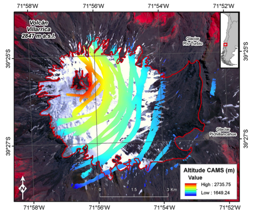
Figure 1 Measurements of surface elevation in the Villarrica Volcano by airborne laser.
To determine the topography of the Villarrica Volcano CECs scientists used a laser system of their own design known as CAMS (CECs Airborne Mapping System), which measures with a vertical accuracy of 20 cm. For these measurements CAMS was mounted on a Piper PA-30 Twin Comanche aircraft.
In addition, ice thickness data was collected using a radar for temperate ice (around melting point) developed by CECs together with the BGR of Hannover, and the private enterprise Unmanned. This system operates at a center frequency of 20 MHz, and owing to its weight and size must be transported by helicopter to perform the measurements.
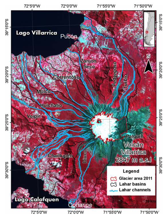
Figure 2 The Villarrica Volcano with channels definition of lahars (blue), and glacial basins (in black), from which they can be caused.
Although the present availability of water would suggest smaller volumes for future lahars it does not mean a lower risk associated with this type of volcanic flows, especially given the significant increase in population in areas around the Villarrica Volcano that has taken place in recent years.
This ice volume study will be useful for modeling possible lahar flows in this part of the volcano. The information has already been provided to the authorities concerned with local emergency planning.
---
Ref.: Recent changes in total ice volume on Volcán Villarrica, Southern Chile. Natural Hazards, January 2015, Volume 75, Issue 1, pp 33-55, DOI: 10.1007/s11069-014-1306-1
|